
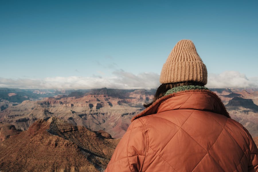
Hiking is one of the best activities that you can be fully enjoyed in Grand Canyon National Park. It is an adventurous activity that empowers your stamina and self-determination. As Grand Canyon National Park conquers a vast land area, it opens the way to several hiking trails. These trails will lead you along with spectacular sceneries that very rarely can be seen. But, what are the best hikes in Grand Canyon National Park? Some of the hiking trails could be easy or hard. So, let’s find out and get to know what are the best hikes in Grand Canyon National Park.
There are numerous hiking trails in Grand Canyon National Park. About 133 hiking trails are available for your hiking adventure. But, as you know these hiking trails could be somewhat dangerous. So, it is better to select a trail that is both safe and easy. Here are the 11 best hikes in Grand Canyon National Park that are suitable to collect more experience for your travel book.
- Rim Trail
- Bright Angel Trail
- South Kaibab Trail
- Bright Angel Point Trail
- North Kaibab Trail
- Havasupai Trail
- Grandview Trail
- Widforss Trail
- Cape Final Trail
- Hermit Trail
- Rim-to-Rim Trail
People admire Grand Canyon National Park mostly because of hiking. The best time for hiking in Grand Canyon is in May, or Spring and Fall. Temperature is the most important fact for hiking for a safe and better hiking adventure. If you expect to go for a hike in Grand Canyon National Park, visit one of these better seasons to have a great experience of hiking.
So, now let’s find out and get to know what the 11 best hikes in Grand Canyon National Park are.
Rim Trail
- Difficulty: Easy
- Trail Distance: Up to 13 miles
- Trailhead elevation: 6,820 ft
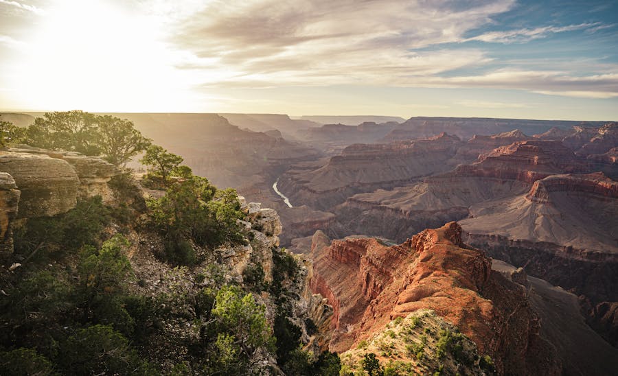
This is the most famous hike in the Grand Canyon National Park. This trail stretches for about 13 miles from Hermit’s Rest to the South Kaibab trailhead. The trail is completely flat and shaded. So, you can hike easily. You do not have to hike the whole trail. You can hike as much as you can and turn back to a shuttle stop that is located all along the way. The bus departs every 15 minutes. So, you can head back to find your vehicle without any issue. Also, there is no water along the trail. Water is available at Hermit’s Rest, Bright Angel Trailhead, within Grand Canyon Village, and South Kaibab Trailhead.
Hiking Trail Highlights
The South Rim
The South Rim of the Grand Canyon consists of 3 sections: Grand Canyon Village, Desert View Road, and Hermit Road. By visiting these sites, you can experience the beauty of incredible viewpoints.
Colorado River
This river flows from the Southwestern United States and Nothern Mexico. As the Colorado River rolls through the rocky canyons, it adds beauty to the Grand Canyon National Park. Hikers love to watch the sunset over the Colorado River.
Bright Angel Trail
- Difficulty: Strenuous
- Trail Distance: 9.3 miles
- Trailhead elevation: 6,860 feet
Bright Angel Trail is the most popular rim-to-rim trail in Grand Canyon National Park that offers several spectacular views. This trail is steep and has shadows on it from the canyon walls. The upper portion of the trail is extremely icy in winter or early spring. However, the wide views of the inner canyons and distant formations always keep you distracted from how far they have been walked. As water is available seasonally, from May to October along the trail at 1½ – Mile Resthouse and 3 – Mile Resthouse and as well as year-round at Indian Garden.
Hiking Trail Highlights:
There are 7 locations along Bright Angel Trail that are usually considered stops.
First Tunnel
This is 0.18 miles one way, 0.36-mile round trip, and 6,708 feet elevation at the tunnel. This part of the trail is not steep. However, it is a good place to experience a view from within the canyon.
Second Tunnel
You will come across this second tunnel 1.8 miles after the beginning of the trail.
1½ – Mile Resthouse
There is water here that is available seasonally. Also, restrooms and an emergency phone are available for hikers. This place is considered a good turn-a-round for casual hikers if they got a late start.
3 – Mile Resthouse
After 1½ – Mile Resthouse, the trail gets steeper. There is water that is seasonally available. You can get the service of the emergency phone that is available here. But, there are no restrooms available. Many people tend to turn around here.
Indian Garden
Indian Garden is the halfway point on the trail. The National Park Service warns day hikers not to go past after this point, especially in Summer. You can also watch some remains of ancient structures built by Puebloan and Cohonians native Americans.
Plateau Point
The National Park Service is advised not to do this as a day hike unless you do not have lots of water and leave early. When you reach here, you will come across the oldest rocks in the Grand Canyon. It is narrow and you can watch the view of the Colorado River and Grand Canyon from here which are spectacular.
Old Devil’s Corkscrew
However, after reaching the Colorado River, you will meet Old Devil’s Corkscrew which is a switchback. But this is not severe as the name it has got.
River Resthouse
River Resthouse is 8 miles from the start of the trail that has 2,480 feet of elevation. This is the spot where the trail meets the river. Also, it is the official end of the Bright Angel Trail. There is an only emergency phone available here.
The Bright Angel Suspension Bridge (Silver Bridge)
This is 9.2 miles from the Bright Angel Trailhead at 2,460 feet elevation level. It is a narrow suspension bridge that crosses the Colorado River.
South Kaibab Trail
- Difficulty: Strenuous
- Trail Distance: 7.1 miles
- Trailhead elevation: 7,260 ft
The South Kaibab Trailhead is the first trail from the rim to the river that was built by the Parks Service. The trail is located near Yaki Point. During the Winter season, the trail can be covered with snow. In Summer, it gets hot as there is not much shade on the hike. However, there is no water along the trail. So, you have to take water with you. No private vehicle is allowed at the trailhead. You have to access it either by foot or bicycle. Or else, you can get to the trailhead by taking the free Grand Canyon shuttle from the Visitor Centre directly to the trailhead.
Hiking Trail Highlights:
Ooh Aah Point
This delivers spectacular views. It is at 790 feet of elevation and 1.8 miles away from the start.
Cedar Ridge
When you reach here you will experience the eye-catching views of the Grand Canyon. Cedar Ridge is 3 miles away from the start and situated at 1,120 feet of elevation.
The Tipoff
From here you can see some views of the Colorado River. It is 9 miles away from the start and located at 3,280 feet in elevation.
Bright Angel Point Trail
- Difficulty: Easy
- Trail Distance: 0.5 miles
- Trailhead elevation: 8,100 feet
This short walk trail is located at the North Rim of Grand Canyon National Park. The trail begins on the Bridle Path behind the Visitor Center or from the Grand Canyon Lodge veranda. There is no water available on the trail.
Hiking Trail Highlights:
Bright Angel Point
This is the most popular viewpoint on the North Rim. Most visitors experience the most stunning views by visiting here. You will come across this viewpoint at the end of the trail.
Roaring Springs
Roaring Spring is a majestic sight that looks like something in a fairytale. This is the main water supply for both the North and South Rim.
North Kaibab Trail
- Difficulty: Strenuous
- Trail Distance: 14 miles (23 km)
- Trailhead elevation: 8,060 ft (2,460 m)
This is one of the most difficult and least visited trails of inner canyon trails in Grand Canyon National Park. For day hikers this trail would be more challenging. You do not need to worry about water as it is available at North Kaibab Trailhead and North Rim Backcountry Information Center. You can get portable water at Supai Tunnel, Manzanita Rest House, and Cottonwood Campground.
Hiking Trail Highlights:
Coconino Overlook
This is 6.0km away from the start of the North Kaibab Trail. Hikers can enjoy the sceneries of the mighty canyon peacefully due to the less crowd.
Supai Tunnel
Supai Tunnel leads you through the ancient rocks of the Grand Canyon. Here you can enjoy the service of restrooms and water. It is about 1.5 miles away from the North Kaibab Trail.
Redwall Bridge
This is 2.6 miles away from the North Kaibab Trailhead. After passing this destination you will reach Roaring Springs and Cottonwood Campground.
Havasupai Trail
- Difficulty: Strenuous
- Trail Distance: 10 miles
- Trailhead elevation: 2,500 feet
The Havasupai Trail begins from the Hualapai Hilltop and stretches for 10 miles. The trail was well-maintained and about 10 feet wide with small rock walls on its sides. The best time to hike Havasupai Trail is from February to November. During the SUmmer the trail is closed due to the extreme heat. There is no water available on the trail. So, you need to bring water with you.
Hiking Trail Highlights:
Havasu Creek
A stream in Grand Canyon National Park that is associated with the Havasupai people. It is a tributary to the Colorado River.
Supai Village
This is located at the bottom of Havasu Canyon. It is the home to the Havasupai tribe who have been living in the Grand Canyon for about 800 years. This is the most isolated village in the US.
Havasu Falls
Havasu Falls is located 1½ miles from Supai. It is the most famous and most visited fall in the Grand Canyon National Park.
Havasupai Campground
This is located along Havasu Creek. It is a great place for camping and it provides you with composting toilets, picnic tables, and drinking water.
Grandview Trail
- Difficulty: Strenuous
- Trail Distance: 12 miles
- Trailhead elevation: 7,400 feet
The trail begins on the east side of the stone retaining wall at Grandview Point. This is a rocky and exposed trail that requires experience and caution. So, this is only for experienced desert hikers. There is no water available on the trail.
Hiking Trail Highlights:
Coconino Saddle
The trail gets steeper and more tricky beyond Coconino Saddle. This place offers spectacular views looking south into the upper valley of Hance Creek.
Horseshoe Mesa
This is a 5,246-foot elevation summit located in the eastern Grand Canyon. Horseshoe Mesa looks like a horseshoe, legs facing due-north towards Colorado.
Grandview Point
Grandview is a popular viewpoint that offers panoramic views of the Grand Canyon from east to west.
Page Spring
The Page Spring Trail in Grand Canyon National Park connects the Grandview Trail and Tonto Trail. The trail connects with Grandview Trail at Horseshoe Mesa.
Widforss Trail
- Difficulty: Moderate
- Trail Distance: 5 miles
- Trailhead elevation: 8,380 ft (2,550 m)
The Wildforss Trail will take you to the characteristic landscape of the Grand Canyon and provides you with expansive views to enjoy yourselves. There is ample parking and a single restroom at the trailhead. Though the temperature is somewhat cooler in the North Rim, it is better to bring water along the hike. You can start your hike early to avoid excessive heat, especially in the Summer.
Hiking Trail Highlights:
Harvey Meadow
This was used as a tourist camp and staging area for cross-canyon mule trips.
The Transept
This is a steep that is on the west of Grand Canyon Lodge and North Rim Campground.
Widforss Point
From this viewpoint, the picnic spot at the end of the Wildforss Trail can just be seen in a clearing at the edge of the forest, shortly before the land starts to slope down steeply. To the South, this point looks out another long ridge of the Supai and Redwall layers.
Cape Final Trail
- Difficulty: Moderate
- Trail Distance: 2.1 miles
- Trailhead elevation: 8,050 feet
The Cape Final Trail is an out-and-back trail with a perfect scenic viewpoint over the Grand Canyon North Rim. It begins from Cape Royal Road. The hiking trail is shaded by forest and it adds a unique beauty to the northern canyon views. There is no water available along the road.
Hiking Trail Highlights:
Ponderosa Pine Forest
When you travel along Cape Royal Road, you will come across Ponderosa Pine Forest which symbolizes the greatest ecosystem of Grand Canyon National Park.
Cape Final
The hikers who walk for more than 2 miles will meet this amazing viewpoint. This offers you great scenarios of the Painted Desert beyond the Grand Canyon.
Hermit Trail
- Difficulty: Very Strenuous
- Trail Distance: 8,9 miles
- Trailhead elevation: 4,240 feet
The Hermit Trail is the most difficult and less-visited hiking trail in Grand Canyon National Park. You can not hike this trail within a day. So, many hikers stay at Hermit Creek Campground at night. The trailhead can be accessed by shuttle bus from Grand Canyon Village, on Hermit Road. However, all water sources along this trail should be filtered, treated, or boiled before drinking.
Hiking Trail Highlights:
Santa Maria Spring
This is a permanent water source next to a stone shelter with benches, which is reached after 2 miles. You can enjoy the views of the sheer red cliffs around the upper end of Hermit Creek.
Breezy Point
Breezy Point is a promontory that gives a fine panorama over the inner canyon gorge.
Cathedral Stairs
This is a cliff inside of Grand Canyon National Park. This is situated nearby to Breezy Point and close to Cope Butte.
Rim-to-Rim Trail
- Difficulty: Extremely strenuous
- Trail Distance: 23.5 miles
- Trailhead elevation: 5761 feet
The hike begins from North Kaibab Trail on the North Rim and connects with the Bright Angel Trail on the South Rim. You have to request rim-to-rim permits 3 or 4 months before the hike. You have to be hydrated throughout the hike as it is hard. The best time to do a Rim-to-Rim hike is during May, September, or October.
Hiking Trail Highlights:
Plateau Point
This is a point on a platform of a cliff-formed rock unit. It is a 3,789 feet cliff-elevation point in the Grand Canyon.
Historic Navajo Bridge
This is the name of the twin steel spandrel arch bridge that is built across the Colorado River in the Grand Canyon National Park.
Ribbon Falls
Ribbon Falls is also accessible from the Phantom ranch. This is the only waterfall in Grand Canyon National Park that is accessible without backpacking or rafting.
Guide to 11 Best Hikes in Grand Canyon National Park
- Bring plenty of water
- Use extreme caution when hiking in the Summer
- Don’t hike to the Colorado River and back in a single day.
- Keep a distance from mules
- Try to bring plenty of food
- Check the weather condition before arriving
- Get to know the geology of Grand Canyon National Park
- Travel as light as possible
- Use hiking sticks to stress off your legs
- Dress appropriately (wear good shoes)
These are the most popular and safe hikes in Grand Canyon National Park. Grand Canyon National Park is a beneficial site that saves both your time and money. By visiting here you will be able to do many things at once. You can engage in activities like camping, hiking, riding mules, scenic driving, wildlife watching, and visiting several places of importance. But, among all of these activities, hiking seems to be more popular among visitors.
Read More: